By BRENDAN M. LYNCH
KU News Service
LAWRENCE — For Jude Kastens, who grew up on a farm in northwest Kansas, rainfall always was serious business. Although flooding wasn’t as big a problem in his hometown as in central and eastern Kansas, it was “always memorable” when heavy rain caused local streams to swell from their banks into surrounding river valleys.
“Being a farm kid in rural Rawlins County shaped my interests in geography, weather and the environment,” Kastens said. “I got my degrees in math at KU and eventually transitioned into applied geospatial work.”
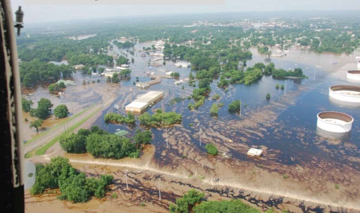
Now, he works as a research professor at the Kansas Biological Survey & Center for Ecological Research at the University of Kansas, where he still watches for extreme rainfall in Kansas and beyond. Kastens, who directs the Kansas Applied Remote Sensing (KARS) program at the Biological Survey, recently oversaw launch of the Kansas Flood Mapping Dashboard, a cutting-edge digital tool for emergency managers across the state as well as the public.
“The dashboard grew out of our flood modeling research,” Kastens said. “We started building it after the 2019 floods, and it’s been evolving ever since. It’s now a web-based system that automatically maps flood extent and depth in near real time. When a natural disaster strikes, the State Emergency Operations Center activates, and flooding is frequently in focus. This tool gives them a clear picture of where the water is and how deep it’s expected to be along most major Kansas waterways.”
The Kansas Flood Mapping Dashboard uses stream gauge data from the National Weather Service and the U.S. Geological Survey, among other sources, along with the terrain-based FLDPLN (“Floodplain”) model developed in Kastens’ 2008 dissertation to generate flood inundation maps.

“We’ve automated the maps to update every two hours,” Kastens said. “Over the years, a big part of my research has focused on flooding. It started with mapping river valleys, which are historic floodplains – using hydrologic flow principles applied to terrain data. After realizing we could convert river stage readings to realistic flood inundation maps, we began to develop the Kansas flood mapping system.”
KARS works with Kansas state agencies like the Kansas Water Office and the Department of Agriculture to provide research that helps them better understand and manage land and water resources across the state.
“One of my biggest drives is to utilize science and research for the benefit of the state. Developing applications that get used makes me happy,” Kastens said.
Kastens also was part of a team to report new flood mapping research in a scholarly paper recently featured on the cover of the peer-reviewed journal Remote Sensing.
“The approach is called ‘FLDSensing,’” said the KU researcher. “It uses the FLDPLN model and floodwater boundary points extracted from satellite imagery to estimate floodwater extent and depth. If you know the location of a flood’s shoreline, that’s essentially a proxy gauge. This research demonstrates how edge-of-water coordinates from the field could be used for area-wide flood mapping in the absence of stream gauges.”
The lead author of the study is Jackson Edwards, whose master’s research at KU produced the work. Other co-authors include David Weiss and Xingong Li of KU; Francisco Gomez, Hamid Moradkhani and Sagy Cohen of the University of Alabama; and Son Kim Do and Venkataraman Lakshmi of the University of Virginia.
While Kastens headed work that led to the flood mapping dashboard, he stressed it was a “total” team effort.
“A lot of people contributed to this project,” Kastens said. “My colleague Xingong Li, professor in the KU Department of Geography & Atmospheric Science, laid the groundwork for the real-time mapping, and we’ve had several researchers and graduate students involved over the years. KARS researcher and PhD student David Weiss is the lead architect of the current dashboard, which received praise from the Kansas Division of Emergency Management for its responsiveness and accuracy during severe spring flooding earlier this year.”
Kastens said his group would continue making improvements to the dashboard, with next steps aimed at completing coverage for the western one-third of the state and incorporating roadway impacts. Support from Kansas NSF EPSCoR ARISE is helping with the latter effort.
“The goal is to make this resource as helpful as possible for the public and our emergency responders during a flood event,” he said